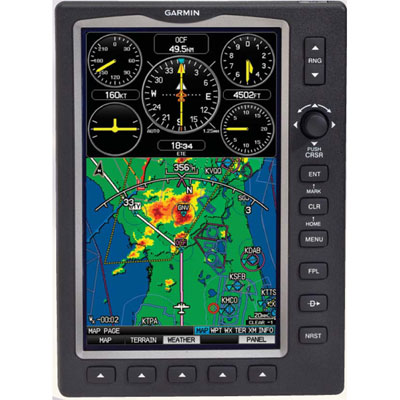
| Garmin 696
Now with geo-referenced charts –
shows your airplane on the approach plate!
Combining advanced glass cockpit
features with Garmin’s biggest screen ever, the new Garmin 696
is truly a portable multi-function display (MFD). In one unit,
Garmin has combined moving map, XM weather, terrain alerts,
charts, airport information and much more. It even qualifies as
a Class 1/Class 2 Electronic Flight Bag (EFB).
Here’s why you’ll love it:
- Huge screen. The
7” diagonal screen is the largest screen available on a
portable GPS, and features an impressive 800 x 480 pixel
resolution. Weather graphics, terrain alerts and simulated
instruments have never looked better, and charts can be
shown at almost full resolution. The screen is also
extremely bright, for superior readability in bright
sunlight.
- Easy-to-use
controls. The 696 features a Garmin G1000-style
joystick that allows you to click, pan and twist,
dramatically reducing data entry time. Soft keys
automatically change function depending on the screen being
viewed, to reduce the number of pages you have to scroll
through.
- Charts. Finally,
an easy way to view digital charts in the cockpit, with no
extra wires or CDs to load. The 696 comes preloaded with all
FAA/NACO approach plates, including arrivals, departures,
airport diagrams and approaches. Charts can be viewed at
nearly full size, or can be enlarged for easier reading. It
even shows your airplane's position on the chart as you fly
down final--a great help for situational awareness. Also
works with JeppView charts (separate subscription required).
- XM Weather. A
hugely popular feature from the 496 and 396, XM weather is
even better on the Garmin 696. Weather products can be
viewed independently or overlaid on the main map page, all
in a large, easy-to-read size. The included XM Weather
antenna displays NEXRAD radar, satellite images, METARs,
TAFs, TFRs, turbulence forecasts, winds aloft, freezing
levels and much more (requires separate subscription).
- Compatible with GDL
39 ADS-B Receiver. Get subscription-free weather
and traffic in-flight with the GDL 39 (sold separately)
- Simulated instrument
panel. Pilots have come to love Garmin’s simulated
instrument panel, which displays GPS-derived instruments for
speed, altitude, vertical speed, bank angle and heading. On
the Garmin 696, this feature can be viewed directly on the
map page as a split screen—no scrolling required—for
unbeatable situational awareness.
- Terrain. A
dedicated terrain page shows nearby terrain and obstacles,
and the 696 also includes a profile view that shows a side
view of upcoming terrain. Terrain can also be overlaid on
the main map page. Finally, pop-up alerts warn you of
potential danger no matter what page you are viewing.
- AOPA Airport
Directory. The most comprehensive collection of
airport and facility information, AOPA’s Airport Directory
shows FBO services, ground transportation, hotels, area
attractions and much more. This is in addition to a full
Jeppesen® database of runway lengths, frequencies and
approach waypoints.
- Taxiway Maps. SafeTaxi™
maps show you detailed airport diagrams for over 650
airports, including hold short lines, ramp areas and taxiway
labels. And, your airplane’s position is shown on the map,
minimizing the risk of runway incursions.
- Truly Portable. Unlike
hard to use computers or electronic flight bags, the Garmin
696 includes an internal battery and internal GPS antenna.
You can fly completely wire-free if needed, making it
invaluable as a backup navigation source.
Measures 5 3/4"”l x 7 3/4”h x 1
1/2”d; weighs 2.3 lbs.
Includes: GPS
unit with internal battery and GPS antenna, external XM weather
antenna, external GPS antenna, protective cover, USB interface
cable, yoke mount, wall charger, 10-36V power plug, free
Jeppesen® update, quick reference guide, owner’s manual.
Chart updates:
digital charts are updated every 28 days, and can be easily
downloaded from fly.garmin.com. One-time updates are $95; a one
year subscription is $395.
Americas Coverage includes
North, South and Central America including Hawaii.
|